Scriptcraft For Creating Topography In Minecraft
I’m finding ScriptCraft is an excellent way to motivate my son to learn programming. Walter Higgins has created a fantastic environment for interacting with the minecraft world. First steps can be taken from within the game itself, manipulating blocks to create houses and geometrical shapes. Next, you can save your programs as files and reload the code as you edit it in a text editor.
The most impressive part of ScriptCraft so far is the excellent introductory documentation. When I first showed my son the system, I could only give him the briefest of introductions as I had a phone meeting to attend. Then I pointed him at the Young Person’s Guide to Programming Minecraft and had to call into the meeting. I was worried that he was going to get frustrated and give up…but after the meeting he was still happily exploring and creating houses, spheres and blocks in the minecraft world–all by himself. Granted, he has learned some basic JavaScript before, but it was wonderful that he was able to get going so easily. The other minecraft mod systems could take a lesson from this as I have found their documentation only covers the very basics.
After learning the basics of ScriptCraft, we wondered if we could recreate our local region in minecraft?
Digital Elevation Models in MineCraft
As you can see, the Minecraft Oregon is nearly indistingushable from the actual Oregon
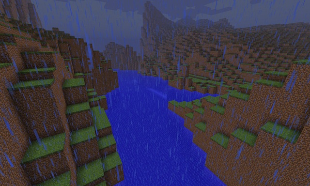
With ScriptCraft, the Geospatial Data Abstraction Library (GDAL) and some basic programming, I was able to get our local region’s topography into minecraft and posted my first picture on twitter. After a request from @walter on twitter to describe the process, I’m writing it down here.
I’m metaphorically standing on the shoulders of Bjørn Sandvik who wrote this blog entry that enabled me to decode the DEM data easily.
Here is the overview of the process:
- Get the GDAL software package.
- Get the elevation data.
- Create & crop a greyscale image where the grey level is proportional to the height in your elevation data.
- Use that greyscale image to also create a material image. Different colors in this image represent different materials like water, grass, sand, etc.
- Convert these images to JSON-formatted arrays.
- Finally, create a ScriptCraft function to use the data in the arrays to create the topography in Minecraft.
Getting the GDAL software package
From Bjørn’s site, I discovered the GDAL
software package. Happily, it was easily installed on Ubuntu
12.04 LTS via sudo apt-get install gdal-bin.
GDAL enables the conversion of elevation files to images. Images are easier to use for the rest of the process than the special-format DEM files.
Getting Elevation Data
Of course, you’ll need to get the basic topography for your region. These are found in Digital Elevation data or DEM files. For myself, I found this site for Oregon DEM files via a google search. I believe that DEM files are also available via http://earthexplorer.usgs.gov/, but I have not used this service yet.
You will want to know the exact latitude and longitude of the region you want to model in order to find the DEM file (or files) you need. As always, Google is your friend here.
After a bit of tedious downloading and looking inside files via the gdalinfo program, I found that the data I wanted was in this DEM file: ftp://159.121.106.159/elevation/DEM/baseline97/rawdems/45122/d/5122d6dg.zip
Create Elevation Image
Unzipping the one DEM file I needed, I followed the steps from Bjørn’s site.
# Build a virtual dataset. (I only used one DEM file)
> gdalbuildvrt lakeo.vrt 5122D6DG
# Convert virtual dataset into a GeoTIFF
> gdalwarp lakeo.vrt lakeo.tif
# Get relevant info from the GeoTIFF file.
> gdalinfo -mm lakeo.tif
# in the output, these lines were the most relevant
Size is 328, 466
Pixel Size = (30.0, -30.0)
Computed Min/Max=0.000,1064.000
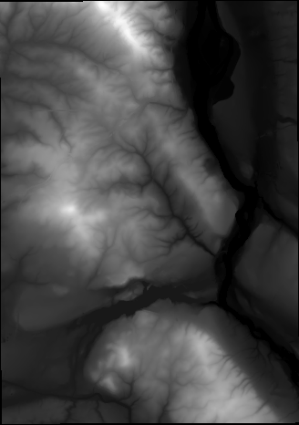
# Given the min/max info, scale it to fit in an 8-bit PNG
> gdal_translate -scale 0 1064 0 255 -of PNG lakeo.tif lakeo.png
These steps create a 328x466 image where the normal 0 to 1064 meter elevation is encoded in the greyscale values between 0 to 255.
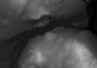
I was a bit worried (for good reason, I found later) that a region
this size would take too long to create in minecraft. Because this is
just a PNG image, I used gimp to select a
smaller 200x140 pixel area to use. I just cropped and saved this as
lakeo_clip.png.
Create Material Image
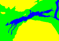
At this point, you can create a heightmap of the terrain, but to have different types of terrain, including water for a lake, you need some additional data.
By converting this greyscale image to a RGB color image and using the select-color tool in gimp, I was able to create a 3-color (blue, green, yellow) map to use for describing the different materials to place in minecraft.
Convert Images to JSON
Now, we need to get this image information into a format that is usable in Javascript. There are a lot of ways to do this and I chose to use the python Image module.
#!/usr/bin/python
import Image
import json

# load elevation data
i = Image.open("lakeo_clip.png")
d = i.load()
width = i.size[0]
height = i.size[1]

heightmap = []
for y in range(height):
    hh = []
    for x in range(width):
        # y-invert image
        hh.append(d[(x,height-1-y)][0])
    heightmap.append(hh)

# convert color data to 0,1,2
def color2blk(c):
    if c == (255, 255, 0, 255):
        # yellow = high elevation
        return 2
    elif c == (0, 255, 0, 255):
        # green = low elevation
        return 1
    elif c == (0, 0, 255, 255):
        # blue = water
        return 0
    else:
        print "Bad Color:",c
        assert(0)

# load color data
i2 = Image.open("lakeo_clip2.png")
b = i2.load()
assert i2.size[0] == i.size[0]
assert i2.size[1] == i.size[1]

blockmap = []
for y in range(height):
    hh = []
    for x in range(width):
        # y-invert image
        blk = color2blk(b[(x,height-1-y)])
        hh.append(blk)
    blockmap.append(hh)

data = { "width": width,
         "height": height,
         "elevation": heightmap,
         "blocks": blockmap,
     }

with open('lakeo_clip.json', 'w') as outfile:
    json.dump(data, outfile)
Hopefully the code is self-explanatory. It is just converting the PNG imagery into 2D arrays and saving them as JSON data. One thing to notice is that I y-invert the image. This is because the JavaScript code creates terrain assuming the origin is in the lower-left of the image. But, the PNG data is stored starting from the upper-left. Y-inverting fixes this mismatch.
I just copied the relevant parts of the JSON file as text and pasted it into the JavaScript function described in the next section.
Create the ScriptCraft Function
The ScriptCraft function I created to instantiate the elevation data
is in this
gist. The
interesting part is copied below, but the gist also has the elevation
data stored in the lakeo_elevation and lakeo_blocks 2D arrays.
The code rasterizes the terrain and creates boxes with 3x3 bases where
the height is derived from the lakeo_elevation array. You can
adjust as you’d like. Fullscale would have this basic block as 30x30,
but we liked the exaggerated reality of a 3x3 block.
For each type of material, I create a lower layer and a top layer to give a bit of interest to the topography. This could certainly be made more interesting, but this is just V1.0…
var lakeo = function() {
    // saves the drone position so it can return there later
    this.chkpt('lakeo');
    var x, y;
    // each block is 3x3.
    var w = 3;
    for(y = 0; y < 140; y++ ) {
        for(x = 0; x < 200; x++) {
            var h = lakeo_elevation[y][x];
            var b = lakeo_blocks[y][x];
            if(b === 0) {
                // water
                var h2 = w*4;
                var h1 = h - h2;
                if(h1 > 0) {
                    this.box(blocks.clay,w,h1,w)
                        .up(h1)
                        .box(blocks.water,w,h2,w)
                        .down(h1);
                } else {
                    this.box(blocks.water,w,h,w)
                }
            } else if(b === 1) {
                // grass-covered block
                var h2 = w;
                var h1 = h - h2;
                if(h1 > 0) {
                    this.box(blocks.dirt,w,h1,w)
                        .up(h1)
                        .box(blocks.grass,w,h2,w)
                        .down(h1);
                } else {
                    this.box(blocks.grass,w,h,w)
                }
            } else if(b === 2) {
                // high grass-covered block
                var h3 = w;
                var h2 = w*3;
                var h1 = h - h2 - h3;
                if(h1 > 0) {
                    this.box(blocks.stone,w,h1,w)
                        .up(h1)
                        .box(blocks.dirt,w,h2,w)
                        .up(h2)
                        .box(blocks.grass,w,h3,w)
                        .down(h1+h2);
                } else {
                    this.box(blocks.grass,w,h,w)
                }
            }
            this.right(w);
        }
        this.left(x*w).fwd(w);
    }
    // return to where we started
    return this.move('lakeo');
};
// Okay this extends the drone object to include this fn
var Drone = require('../drone/drone').Drone;
Drone.extend('lakeo',lakeo);

// ...code continues with the 2D arrays of data...
So, with this file in your plugins directory, at this point you should face toward north, point at a square in front of you and type:
/js lakeo()
and watch the topography be created. Be warned, it takes several hours to finish. You may want to start small (10x10 instead of 200x140) if you are experimenting on your own. If anyone has ideas on how to make this run faster, I’d love to hear about it.
I’ve dashed this off quickly so I may have missed some details. I’m also new to ScriptCraft so I may not be doing something as well as could be done. Let me know on twitter if I need to fix something. But, I hope this shows how you, too, can model your neighborhood terrain in Minecraft.
Cheers!